|
|
|
Click here for a text version with more information.


W Region, NW Region, N Region, NE Region, E Region.
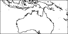
5 grayscale maps covering the cyclone prone regions of Australia from the Equator to 36 degrees South and 96 to 168 degrees East in 24 degree wide overlapping sections, thus ensuring adequate plotting area for any cyclone that could pose a threat to any part of Australia. The black place names are those that would normally be used in Australian Bureau of Meteorology Warnings.
I thank the Australian Bureau of Meteorology for their help with place name and other information that has made these maps much better for the purpose.
Note: These 30 pixel per degree maps will really test your printer. If you get a pronounced 'table cloth pattern' you may need to print them elsewhere and photocopy the result.


WLocal_00-18S, NWLocal_00-18S, NLocal_00-18S, NELocal_00-18S, ELocal_00-18S
WLocal_09-27S, NWLocal_09-27S, NLocal_09-27S, NELocal_09-27S, ELocal_09-27S
WLocal_18-36S, NWLocal_18-36S, NLocal_18-36S, NELocal_18-36S, ELocal_18-36S
15 grayscale maps covering the cyclone prone regions of Australia from the Equator to 36 degrees South and 96 to 168 degrees East in 24 degree wide by 18 degree high overlapping sections. These maps are good for plotting cyclones that threaten specific areas. For places towards the limit of any map, download the adjacent map(s) so you can choose the best map for an approaching cyclone. The black place names are those that would normally be used in Australian Bureau of Meteorology Warnings.
These 30 pixel per degree maps will print well on a larger range of printers than the regional maps above.
This set currently covers the whole of the Australian region. The actual map GIF's are each named with the Long. and Lat. coordinates, so place the cursor on the link to read them.
W_00-12S, WNW_00-12S, NNW_00-12S, N_00-12S, NNE_00-12S, ENE_00-12S, E_00-12S.
W_06-18S, WNW_06-18S, NNW_06-18S, N_06-18S, NNE_06-18S, ENE_06-18S, E_06-18S.
W_12-24S, WNW_12-24S, NNW_12-24S, N_12-24S, NNE_12-24S, ENE_12-24S, E_12-24S.
W_18-30S, WNW_18-30S, NNW_18-30S, N_18-30S, NNE_18-30S, ENE_18-30S, E_18-30S.
W_24-36S, WNW_24-36S, NNW_24-36S, N_24-36S, NNE_24-36S, ENE_24-36S, E_24-36S.
The dark blue place names are those that would normally be used in Australian Bureau of Meteorology Warnings.

Grayscale Hong Kong Regional Tracking Map (v1.6g)

Colour Hong Kong Screen Size Tracking Map (v1.6.1c)
These maps include arcs at 800 km, 600 km, 400 km, 200 km, 100 km, 50 km, and 25 km distances from Hong Kong.
Maintained by Carl Smith.
carls@ace-net.com.au
© Carl Smith 1999 - 2000. All maps, images, and other information on these Web pages is copyright, either by Carl Smith, or by the agencies that produce the satellite images and other weather related information, as indicated in each case. It is essential to obtain permission in writing from the copyright owner before reproducing any of the information on this website in any form whatsoever except for fair purposes of review as permitted under copyright legislation.
DISCLAIMER: Carl Smith is not responsible or liable in any way whatsoever for the manner in which any person, group, or business, chooses to use the information in this website or the consequences thereof. Whilst all due care is taken to ensure the accuracy of the information contained herein, there may be errors, and the information here is not necessarily up to date. All persons are reminded that it is essential to obtain current information from relevent authorities regarding current or potential cyclones.