|
|
|

Twin Cyclones Elaine and Vance Regional Map
- a large area regional map of twin TC's Elaine and Vance. Note: Twin Cyclones Elaine and Vance, both co-existing in the same region, are plotted on on a modified regional map due to TC Vance having retained cyclone status all the way across mainland Australia into the Southern Ocean!
(This is a very large image that may be best viewed by downloading it into your computer and using an image viewer and/or printing it)

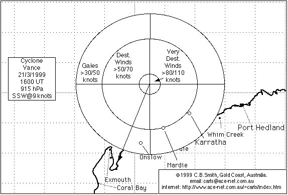
Twin Cyclones Elaine and Vance Local Map
- a Port Hedland to Exmouth local area map of twin TC's Elaine and Vance.
(This is a large image that may be best viewed by downloading it into your computer and using an image viewer and/or printing it)
TC Vance was named on the 18th of March 1999 to the north of the Kimberly coast, had grown to a very destructive Category 5 cyclone on the 21st, and shortly before noon on the 22nd, with maximum wind gusts near the centre estimated to be 300 km/hr, the highest ever Australian mainland wind speed of 267 km/hr was recorded by an official weather station at Learmonth, about 35 kms S of Exmouth. Vance crossed the coast at the base of the Exmouth Gulf between noon and 1pm, and slowly weakened while travelling S then SE across Western Australia, still being a Category 1 cyclone when crossing the coast into the Southern Ocean at around 9pm on the 23rd! For a more detailed account of the passage of TC Vance and TC Elaine in story form, click here.
For more information about TC Vance, go to the TC Vance Track and Report page.
There is a satellite image GIF animation of twin TC's Elaine and Vance, for those who wish to see the view from space of TC Elaine and TC Vance. As TC Vance travelled down the Exmouth Gulf, maximum wind gusts were estimated to be around 300 km/hr! Be warned that the GIF animation is quite a large (2.5 MB) file. It was compiled from trimmed 5-bit grayscale satellite images downloaded from the Satellite Images page of the Australian Bureau of Meteorology (BoM) website.
There is also a synoptic chart animation compiled from charts also downloaded from the BoM.
Maintained by Carl Smith.
carls@ace-net.com.au
© Carl Smith 1999 - 2000. All maps, images, and other information on these Web pages is copyright, either by Carl Smith, or by the agencies that produce the satellite images and other weather related information, as indicated in each case. It is essential to obtain permission in writing from the copyright owner before reproducing any of the information on this website in any form whatsoever except for fair purposes of review as permitted under copyright legislation.
DISCLAIMER: Carl Smith is not responsible or liable in any way whatsoever for the manner in which any person, group, or business, chooses to use the information in this website or the consequences thereof. Whilst all due care is taken to ensure the accuracy of the information contained herein, there may be errors, and the information here is not necessarily up to date. All persons are reminded that it is essential to obtain current information from relevent authorities regarding current or potential cyclones.