|
|
|
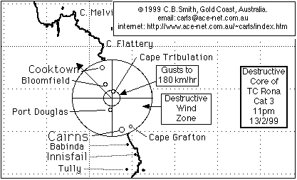

TC Rona - a Cooktown to Bowen local area map of TC Rona.
An example of a small yet severe short-lived cyclone that sprung up very quickly, with only a matter of hours of warning for the communities north of Cairns that ultimately felt the full fury of it's 180 km/hr winds. It demonstrates the need for those who live in cyclone prone areas to pay frequent close attention to the media during the cyclone season (November to May).
For more information about TC Rona, click here - this page was originally on my my brothers website in Hong Kong, where he has assembled the various emails and attached images I sent him into a quite readable page.
Maintained by Carl Smith.
carls@ace-net.com.au
© Carl Smith 1999 - 2000. All maps, images, and other information on these Web pages is copyright, either by Carl Smith, or by the agencies that produce the satellite images and other weather related information, as indicated in each case. It is essential to obtain permission in writing from the copyright owner before reproducing any of the information on this website in any form whatsoever except for fair purposes of review as permitted under copyright legislation.
DISCLAIMER: Carl Smith is not responsible or liable in any way whatsoever for the manner in which any person, group, or business, chooses to use the information in this website or the consequences thereof. Whilst all due care is taken to ensure the accuracy of the information contained herein, there may be errors, and the information here is not necessarily up to date. All persons are reminded that it is essential to obtain current information from relevent authorities regarding current or potential cyclones.