|
|
|
REPORT
On the 3rd of February 2000 at 0124 UTC the BoM Perth issued a warning for Shipping saying that a tropical low with central pressure (CP) 1000 hPa (hectoPascals = millibars = MB) located at 0100 UTC near 11.0S 111.0E moving west southwest (WSW) at 5 knots (KT).
At 10 am WST (030200 UTC), a CYCLONE WATCH was issued for Christmas Island.
At 031400 UTC, JTWC issued a Tropical Cyclone Formation Alert, saying that MetSat imagery at 031130 UTC indicated a circulation centre located near 11.5S 108.7E, approximately 190 noutical miles (NM) ESE of Christmas Island, moving W at 12 KT. Animated infrared satellite imagery revealed persistant but disorganised convection associated with a Low Level Circulation Center (LLCC), UW-CIMSS analysis indicated weak to moderate vertical wind shear over the area, animated water vapour imagery depicted fair outflow aloft, and minimum sea level pressure was estimated to be 1002 MB.
At 040300 UTC, JTWC issued TROPICAL CYCLONE 11S WARNING NR 001 saying that at 040000 UTC it was near 12.1S 107.1E moving 235 degrees at 09 KTS, with max. sustained winds of 30 KT gusting to 40 KT. In the remarks, they said that at 040300 UTC it was near 12.2S 106.8E, S of Java. A recent scatterometer pass indicated an elongated LLCC.
The BoM continued issuing Tropical Cyclone Watches for Christmas Island and regular Shipping warnings until Noon WST (040400) on the 4th, when they issued Tropical Cyclone Advice Number 6 saying the CYCLONE WATCH for Christmas Island has been cancelled. At noon WST tropical cyclone Leon, Category 1, 995 hPa, with maximum wind gusts of 100 km/hr (55 KT), had formed and was located near 12.2 S 106.4 E, 210 kilometres (115 NM) SSE of Christmas Island and moving WSW at 18 kilometres per hour (10 KT). The tropical cyclone should move south of the island this afternoon and tonight. Although freshening westerly winds will be experienced gales are now unlikely on the Island. A shipping warning issued around the same time said Leon was causing rough to very rough seas, moderate swell and 30/45 knot winds within 100 nautical miles of centre, increasing to 50 knots with high seas within 30 nm of centre within 12 hours.
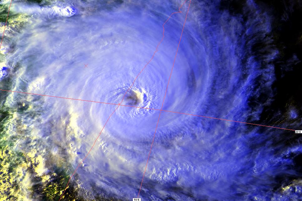
TC Leon quickly gained intensity whilst mainting a WSW then SW track, reaching a minimum CP of 960 hPa according to the BoM at at 1000UTC on the 5th when located near 14.8S 102.8E moving southwest at 8 knots, with it causing very rough seas, moderate to heavy swell and 30/45 knot winds within 100 nautical miles of centre, increasing to 45/55 knots with high seas within 60nm of centre and 65/75 knots with phenomenal seas within 30 nm of centre. The BoM warnings said Leon maintined this intensity until 1600 UTC on the 6th when it was 17.3S 098.5E moving westsouthwest at 12 knots, and CP began to rise in the following BoM warnings.
At 051500 UTC JTWC issued TROPICAL CYCLONE 11S (LEON) WARNING NR 004 saying that at 051200 UTC it was near 14.8S 102.8E moving 240 degrees at 08 KTS, with max. sustained winds of 55 KT gusting to 70 KT, with the radius of 50KT winds being 20 NM and radius of 35 KT winds being 65 NM in the SE semicircle and 45 NM elsewhere, and in the remarks, saying that at 051500 UTC it was near 15.1S 102.5E, approximately 380 NM ESE of the Cocos Islands and was moving WSW at 8 KT. Animated satellite imagery that deep convection had improved over the last 6 hours, however enhanced infrared imagery showed that it was under NE shear as evidenced by a tight thermal gradient along the NE edge of the system and a 050805 UTC Tropical Rainfall Measuring Mission (TRMM) pass depicted a convective band W of the LLCC which wrapped into the NE quadrant of the system, and also showed that inflow had weakened in the NE quadrant.
JTWC warnings showed an increasing intensity reaching a maximum at 070300 UTC in warning NR 007 sayng that at 070000 UTC it was near 17.9S 98.2E moving 245 degrees at 9 KT with max. sustained winds of 70 KT gusting to 85 KT with the radius of the 50 KT winds being 40 NM in the SE semicircle and 30 NM elsewhere and radius of 35 KT winds being 95 NM in the SE semicircle and 85 NM elsewhere, and in the remarks saying at 070300 UTC it was near 18.1S 97.7E, about 360 NM SSE of the Cocos Islands tracking WSW at 9 KT. A 062322 UTC Special Sensor Microwave Imager (SSM/I) pass indicated that the LLCC was located under the NE region of the convection and showed that convection had become more symmetric. The previous 061404 UTC SSM/I pass indicated more of a banding feature wrap. Animated infrared imagery depicted the system had decreased in areal coverage over the past 6 hours and that the W half of it was under the influence of a northerly vertical wind sheer. It also appered that the upper level anticyclone had weakened and shifted E of the LLCC.
The subsequent warnings from both agencies now showed a weakening trend, with the final BoM Shipping warning being issued at 1021 UTC on the 8th saying Tropical cyclone Leon with CP 995 hPa was located at 1000UTC near 17.2S 91.2E moving west at 12 knots, with it causing very rough seas, moderate to heavy swell and 30/40 knot winds within 90 nautical miles of centre in northern quadrants and within 240 nautical miles of centre in southern quadrants. Next warning will be issued by RSMC La Reunion.
The last JTWC warning issued while Leon was still in the Australian area of responsibility was issued at 081500 UTC saying that at 081200 UTC it was near 17.2S 90.4E moving 290 degrees at 14 KT with max. sustained winds of 40 KT gusting to 50 KT and was dissipating as a significant TC over water with the radius of the 35 KT winds being 70 NM in the S semicircle and 55 NM elsewhere, and in the remarks saying at 081500 UTC it had tracked WNW at 14 KT over the last 6 hours. Animated infrared imagery showed the system to be sheared with all the significant convection to the S of the LLCC and 200 MB analysis indicating an upper-level ridge axis to the N creating moderate to strong vertical wind shear over the system. CIMSS satellite analysis indicated an upper-level jet to the SW providing increasingly strong vertical wind shear to the S. The system was forecast to weaken due to vertical wind shear and dissapate within the next 36 to 48 hours.
Whilst the above would be enough to make most think TC Leon was a spent force, subsequent warnings showed a regeneration, it was re-named Tropical Cyclone Eline by RSMC La Reunion, and went on to devastate parts of Madagascar and Mozambique. This part of the journey of TC Leon-Eline will be the subject of a seperate report.
NOTES:
Note 1: Tropical Cyclone Advices, and Shipping Warnings used as sources for meteorological information in this report were issued by the Australian Bureau of Meteorology (BoM) Perth Tropical Cyclone Warning Centre and are Copyright Commonwealth of Australia 2000, Bureau of Meteorology - http://www.bom.gov.au. BoM information is used unless otherwise noted.
Note 2: BoM Perth issues warnings to the Australian public using kilometers for distances, kilometers per hour for maximum gust wind speeds, hPa for central pressure, and times are WST, which is Australian Western Standard Time = UTC +8 hours. I have converted all these and added in them brackets, so changing to nautical miles (nearest 5 NM), knots (nearest 5 KT), hPa = MB, and times are also given in UTC.
Note 3: Joint Typhoon Warning Center (JTWC), Pearl Harbour, tropical cyclone warnings were also used for extra meteorological information where indicated, and that material is copyright JTWC - http://www.npmoc.navy.mil/jtwc.htm.
END REPORT
Maintained by Carl Smith.
carls@ace-net.com.au
© Carl Smith 1999 - 2000. All maps, images, and other information on these Web pages is copyright, either by Carl Smith, or by the agencies that produce the satellite images and other weather related information, as indicated in each case. It is essential to obtain permission in writing from the copyright owner before reproducing any of the information on this website in any form whatsoever except for fair purposes of review as permitted under copyright legislation.
DISCLAIMER: Carl Smith is not responsible or liable in any way whatsoever for the manner in which any person, group, or business, chooses to use the information in this website or the consequences thereof. Whilst all due care is taken to ensure the accuracy of the information contained herein, there may be errors, and the information here is not necessarily up to date. All persons are reminded that it is essential to obtain current information from relevent authorities regarding current or potential cyclones.