|
|
|
REPORT
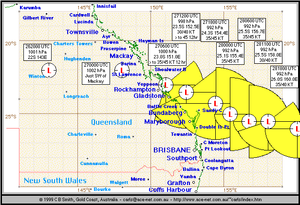
During the 26th of December 1999, monsoonal activity was quite strong across most of Northern Australia and Central Queensland.
A low developed in Central Queensland, which moved into the Coral Sea near Mackay during the 27th, deepening to 992 hPa early on the 28th.
As I live on the SE coast of Queensland, I paid particular attention to this low, which was forecast to move south just off the coast and deepen, generating winds of 45 knots (95 km/hr).
Fortunately for SE Qld, the low continued to move SE to E further from the coast. Gales were experienced on Fraser Island NE of Brisbane during much of the 28th, and severe beach erosion occured on the Sunshine Coast N of Brisbane and to a lesser extent on the Gold Coast S of Brisbane. Heavy rain occurred throughout SE Queensland on the 27th, easing on the 28th, followed by a warm sunny day on the 29th.
As I write this on the 29th, the low has continued in a SSE direction away from the coast, and is moving into the New Zealand area of responsibility. It is forecast to weaken as it moves on a more southerly course into the Tasman Sea.
22S 143E 262000 UTC overland, moving east. Position Poor. Seas South and West of line 19.5S 147E to 19.5S 153E to 25S 153E. Expect NW to E winds increasing to 34/39 knots in the next 12 to 24 hours. Seas and swell increasing to 4 metres.
270000 UTC A broad developing Low with a central pressure of 1002 hPa hectopascals centred inland from Mackay.
A 1000 hPa low near 23.0S 151.0E at 2706000 UTC moving SSE at 10/15 knots and expected to deep. Within 150 nm of centre from radial 050 degrees clockwise through to radial 200 degrees, expect SE to NE winds to increase to 35/45 knots during the next 12 hours. Seas and swell increasing to 4 metres.
A 998 hPa low near 23.5S 152.5E at 2712000 UTC moving SE at 15 knots and expected to deepen. Within 150 nm of centre from radial 050 degrees clockwise through to radial 240 degrees. Expect SE to NE winds 35/40 knots increasing to 45 knots during the next 12/18 hours. Seas and swells to 4 metres.
A 992 hPa low near 24.3S 154.4E at 2718000 UTC moving ESE at 15 knots and expected to deepen and turn more southerly. Within 150 nm of centre in the southern and eastern semi circles. Expect 35 to 45 knots winds N to NE in the NE Quadrant and SE to NE winds in southern quadrants. Seas and swells to 4 metres.
A 992 hPa low near 25.1S 155.4E at 280000 UTC moving SE at 15 knots and turn more Southerly. Within 150 nm eastern sector and within 60nm southwestern quadrant. Expect 35 45 knot winds NW to NE in the eastern quadrants and SE to S in the southwest quadrant. Seas and swells to 4 metres
A 992 hPa low near 25.5S 156.7E at 280600 UTC has been moving east at 15 knots but should take a more S'ly path overnight. Forecast position 281800 UTC 28.5S 157.5E central pressure 992 hPa. Within 150 nm of centre in the eastern semi circle and within 60 nm in the western quadrant. Expect NW to NE winds 35 to 45 knots in the eastern quadrant and SW to SE winds in the western quadrant. Seas and swells to 4 metres.
A 992 hPa low near 25.5S 158.0E at 281100 UTC has been moving east at 15 knots but should take a more southerly path during next 12 to 24 hours. Position fair. Expect SE to NE winds 34 to 40 knots within 120nm of low centre from 050deg radial clockwise to 250deg radial. Very rough seas on a heavy swell.
A 992 hPa low near 26.0S 160.0E at 281800 UTC moving southeast at 15 knots but expected to turn more southerly next 12 hours. Position fair. Expect SE winds 34 to 40 knots within 120nm south of low centre. Very rough seas on a heavy swell.
END REPORT
Maintained by Carl Smith.
carls@ace-net.com.au
© Carl Smith 1999 - 2000. All maps, images, and other information on these Web pages is copyright, either by Carl Smith, or by the agencies that produce the satellite images and other weather related information, as indicated in each case. It is essential to obtain permission in writing from the copyright owner before reproducing any of the information on this website in any form whatsoever except for fair purposes of review as permitted under copyright legislation.
DISCLAIMER: Carl Smith is not responsible or liable in any way whatsoever for the manner in which any person, group, or business, chooses to use the information in this website or the consequences thereof. Whilst all due care is taken to ensure the accuracy of the information contained herein, there may be errors, and the information here is not necessarily up to date. All persons are reminded that it is essential to obtain current information from relevent authorities regarding current or potential cyclones.